What does the
government’s Land Use Framework promise?
Will profit win over nature and agriculture?
Or can the government finally create a
joined up approach to land use
that ensures a secure, healthy and resilient future for all?
Since the Labour government took over the Tories in July
2024, there have been some impressive targets set;
Net zero by 2050
1.5 million new homes by 2029
Clean power by 2030
Food security
30% of biodiversity protected by 2030
Three quarters of rivers, streams and lakes in
good health by 2027
These goals are not just ambitious, but they involve conflicting interests, particularly regarding space which is a limited
resource. Government departments often have a bad reputation for working in
silos and it is startling to think that there has never been a framework that
pulls all these departments together – until this point. Whereas our Scottish
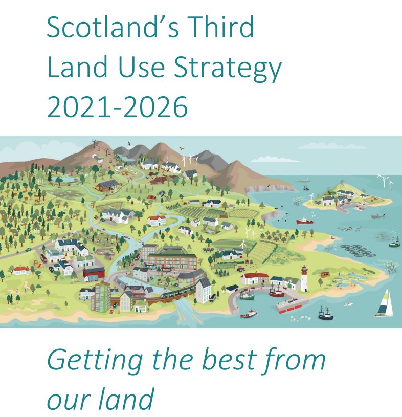
neighbours introduced their first Land Use Framework in 2011 and are currently
implementing their third Land Use Strategy.
What is the Land Use Framework
?
The stewardship of our land is crucial for our economy and society; fundamentally, it is our most precious natural asset. In late January
2025, the government launched an open consultation to discuss their proposed Land Use Framework. This initiative aims to create a vision for how we engage
with both our natural landscapes and urban areas moving forward. Through this
consultation, the government plans to develop a toolkit designed to support land-use decisions that enhance long-term food security, promote sustainable
development, improve ecosystem health, mitigate against the impacts of climate
change, and stimulate economic growth all at once. To realise these goals, a
variety of land use changes will be necessary, and the framework is intended to
steer us toward these transformations to meet our objectives by 2050.
The consultation is open to everyone and closes on the 25th
April 2025, so if you have an opinion on how land is used in this country, this
is the time to have your voice heard.
Source: www.gov.uk
What is ALC and why is it important?
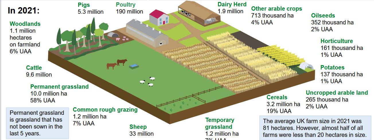
The majority of England’s population occupies urban areas,
with 83% of residents living in cities and towns as of 2020. Despite this, the
land is largely rural (85%) and agriculture occupies 67% of the landscape;
England’s green and pleasant land.
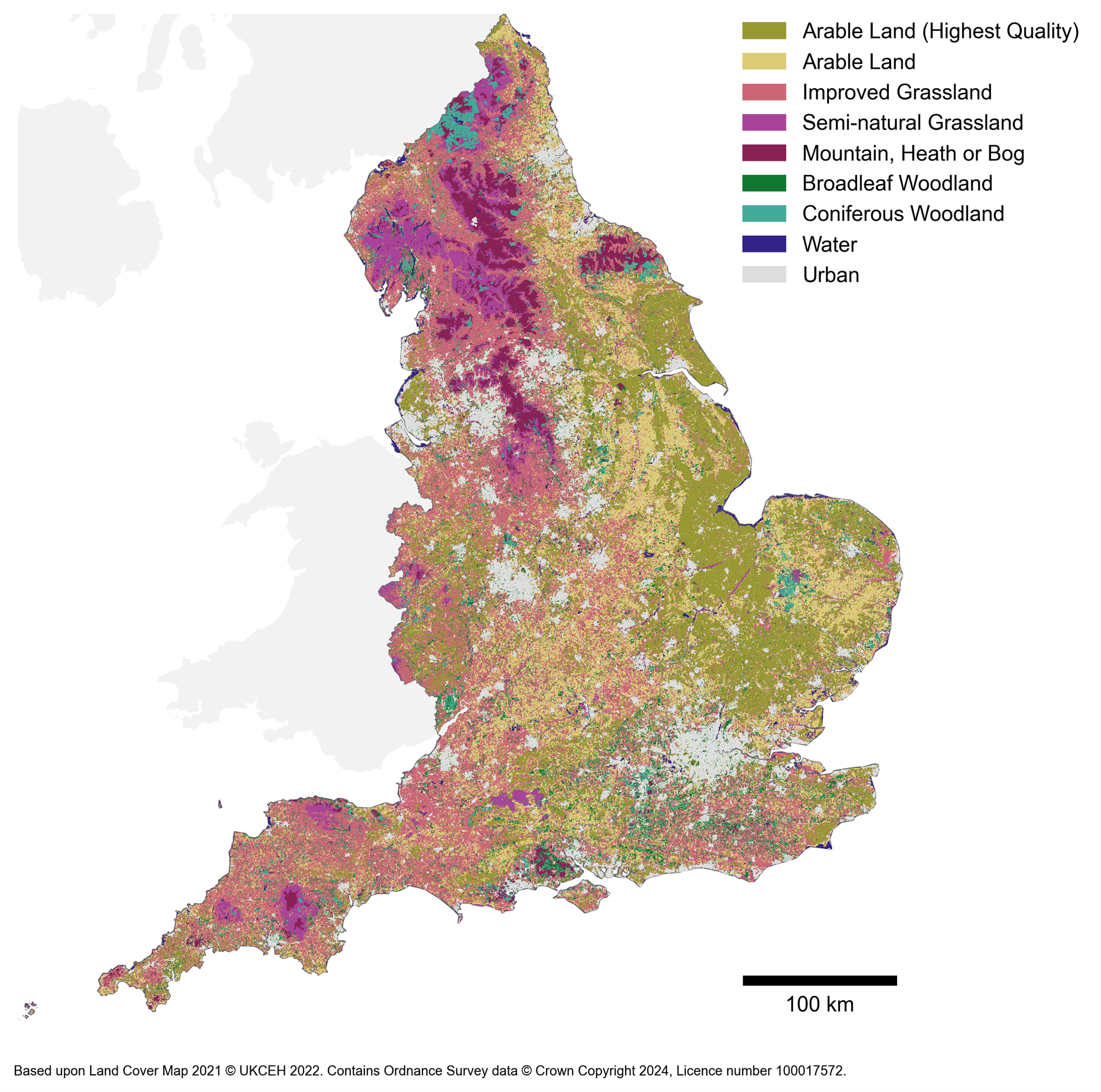
The Agricultural Land Classification (ALC) is a scientific
system which is used to assess the suitability of land for growing crops in
England. There are six grades ranging from Grade 1 which is excellent to Grade
5 which is very poor. The idea behind this system is that development must be
kept away from the best and most versatile agricultural land (Grades 1, 2 and
3a) and steered towards poorer quality land.
The issue with this scientific tool is that it hasn’t been
updated since 1988 and relies on data collected between 1940 and 1980. More
recent assessments of temperature and rainfall would likely show a dramatic
reduction in the availability of high-quality agricultural land. Additionally, information
on lowland peatlands, which support 40% of England’s crops, is based on data
that is half a century old. This vital landscape has faced intensive farming and drainage practices in this time, likely leading to a considerable decrease
in soil quality. Essentially, this suggests that we might be overestimating the
condition of our farmland, while simultaneously masking poor land management practices that could severely threaten our food security if not properly
addressed.
The system fails to account for the diverse soil
characteristics found throughout the country, resulting in soils with vastly
different properties being categorized under the same grade. A report by CPRE in 2022 found that using ALC data in planning decisions has allowed over 14,000
hectares of prime agricultural land being allocated for development. The report
also revealed that 60% of Grade 1 agricultural land is situated in areas at high risk of flooding, posing an increasing threat to our food production.
In summary, the accuracy and reliability of the ALC system
means it is no longer fit for purpose as an appropriate tool for land use
decisions.
Source: www.gov.co.uk
What does the Land Use Framework propose?
Steve Reed, Secretary of State for Environment, Food and Rural Affairs
, said that the land-use strategy, once published this summer, will not be used
to tell people what to do with their land. Instead, it will be “the most
sophisticated land-use data ever published, provide the principles, advanced
data and tools to support decision-making by local government, landowners,
businesses, farmers, and nature groups to make the most of our land.”
The consultation document outlines the principles that the
government have developed in order to support strategic spatial planning and
the targeting of land use incentives:
Co-design: Support
for participation and leadership at the local and regional scale to
develop and align spatial strategies and assess the fairness of changes in
land use.
Multi-functional
land: Enable multiple benefits on land, targeted according to
opportunity, societal needs (such as the health benefits of co-locating
new homes and nature), and environmental pressures (such as reducing
pollution).
Playing
to the strengths of the land: Support and spatially target land
use change to locations where benefits are greater and trade-offs are
lower.
Decisions
fit for the long-term: Take a long-term view of changing land
suitability, prioritising resilience (including to the impacts of climate
change). This could include planning for new homes that are resilient to
climate impacts, such as flooding and overheating.
Responsive
by design: Land use policy, including spatial prioritisation and
targeting, needs to be responsive to new data (including an updated accurate
and comprehensive ALC system), opportunities and pressures.
The consultation asks direct questions such as do you agree or
disagree with the land use principles proposed? Or what approaches could
cost-effectively support nature and food production in urban landscapes and on
land managed for recreation? Followed by space to expand on your views.
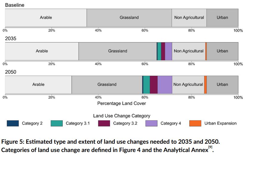
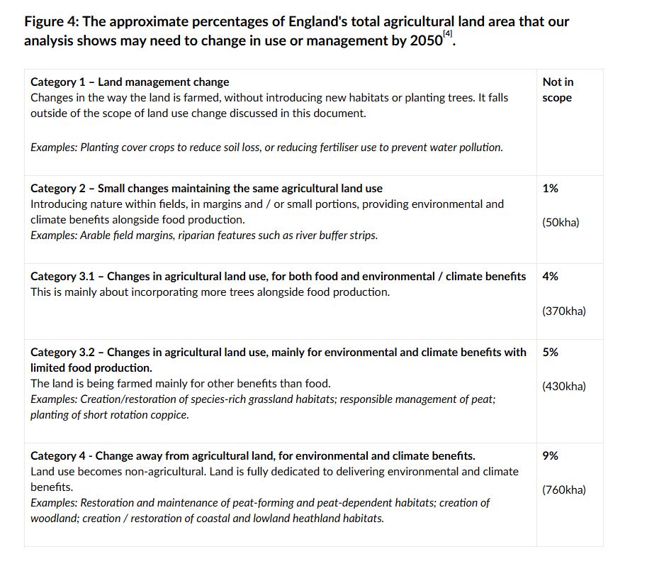
The document also proposes that 10% of farmland will be
switched to non-agricultural uses, but most of this seems to involve
less-productive land, peatland and lowland heath which has been earmarked for restoration.
At the end of the consultation, when a Land Use Strategy is
born, there will also be an interactive map that anyone can use. All the most
current data on our land will be layered into this map from soil health and carbon
sequestration to infrastructure suitability and risk of flooding. It is
a similar approach to the simultaneous multi-layered design method we use here
at R-LA to analyse sites both within and outside the red line boundary at the
start of every project.
Source: www.gov.co.uk
Source: www.gov.scot
Criticism
As with every new government plan, it is not without
criticism. The overriding concern is about putting profit first, when perhaps the
real emphasis should address the needs of the land first. ‘You cannot have
economic prosperity when nature is on its knees,’ says the passionate President of the CPRE, Mary-Ann Ochota. Growth now, nature later simply doesn’t work.
Will the framework really have nature’s back?
The National Farming Union (NFU) is up in arms over the
Inheritance Tax announced last year but they have managed to put together a
blueprint that they hope will play an important role in the framework. “Agriculture, and the farmed environment, is being
short-changed by the planning system. That must end with government matching
its rhetoric with action when it comes to planning reform,” said the
exasperated NFU President Tom Bradshaw at the opening of their annual
conference on Tuesday 25th February 2025.
Sarah Cowie, Senior Policy Manager for Climate Land and
Business at the Scottish NFU was interviewed on BBC Farming Today earlier this
month about the success of Scotland’s Land Use Strategy which is mid-way
through its third edition (2021-2026). She warned that the Scottish NFU had
hoped that the strategy would make hard decisions more straight forward and
that whilst the vision was to be applauded, a pathway is needed for on the
ground action in order to guide the country to a state where agriculture, food
production, biodiversity, climate mitigation and people are better integrated when it comes to policy decisions.
Conclusions
The framework needs to consider these criticisms and the insights
gained from the North. This consultation
presents a vital chance for us to express our views and to ensure that it can
deliver a sustainable future for communities, agriculture and the environment. Without
a solid framework in place, we will be left with contradictory regulations that
result in hasty decisions that fail to tackle the long-term issues at hand.
This is our moment to create sustainable
land management policies that could even streamline the planning process. We
must prepare the land for the impacts of climate change. We must provide the
right incentives for landowners so that the land use change happens in the
right spaces. Keeping spatial data up to date is essential; otherwise – what is
the point?