Confused by Green Belt Rules?
SHARE
Many consider the Green Belt to be the greatest and most successful planning reform since the end of WW2.
With a new National Planning Policy Framework to digest, are we on the verge of losing what's left of our green space, or is this fake news?
We try to dissect the latest policy and ask, can we come up with a sustainable solution in time?
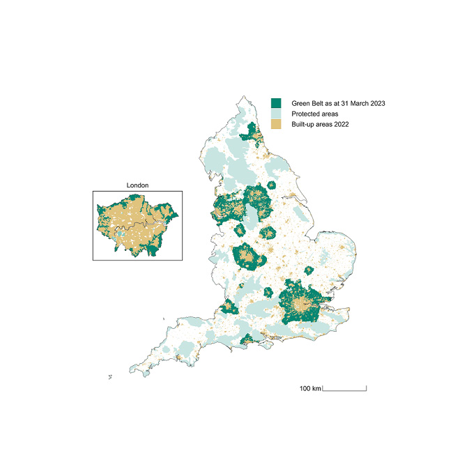
Source: www.gov.uk
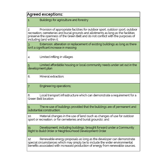
Source: adapted by R-LA from NPPF 2023/2024
1.5 Million New Homes
Labour has pledged to build 1.5 million homes over the next
five years which is around 300,000 new homes a year. As a guide, data in
March 2023 recorded 234,397 houses built within the previous tax year. With
such ambitious targets, a degree of planning reform can hardly be a
surprise. The Conservatives had set equally high projections and both NPPF 2023
and NPPF 2024 agree that if a council is failing to meet affordable housing
targets, this too is an acceptable exception to the Green Belt rules.
However, the 2024 Framework has introduced a colour hierarchy (green, brown, grey) to Green Belt land and it delves into the affordable housing caveat more than
the previous policy which is perhaps the biggest change that people are
concerned about.
“Where it is necessary to release Green Belt land for
development, plans should give priority to previously developed land, then
consider grey belt which is not previously developed, and then other Green Belt
locations.”
According to the NPPF 2024, brownfield sites come under the previously developed land banner (see glossary below). In 2024, Knight Frank released a report which identified 11,205 brownfield sites within the existing Green Belt.
The report predicted that within these 13,500 hectares approximately 200,000
new homes could be built but that is not nearly enough to reach targets. A BBC report has demonstrated the challenging targets that have been set by Labour on local councils and it makes for interesting reading.
The current government defines ‘grey’ as land in the Green
Belt comprising previously developed land and/or any other land that does not
strongly contribute to the unrestricted sprawl of large built up areas, nor prevent
neighbouring towns from merging or that doesn't preserve the setting and special character of
historic towns.

Source: BBC 9th January 2025
The New Golden Rules
The latest NPPF has introduced three final conditions to allow development on the existing Green Belt and these are called the Golden Rules (see table)
. If the housing proposal complies with the golden rules then it ‘should be given significant weight
in favour of the grant of permission.’
Note, the percentage of affordable housing includes small print that states that the cap is 50% unless this would make the development of these sites unviable. This would suggest that ultimately the amount of affordable housing is at the discretion of the planning officer in charge at the local level.
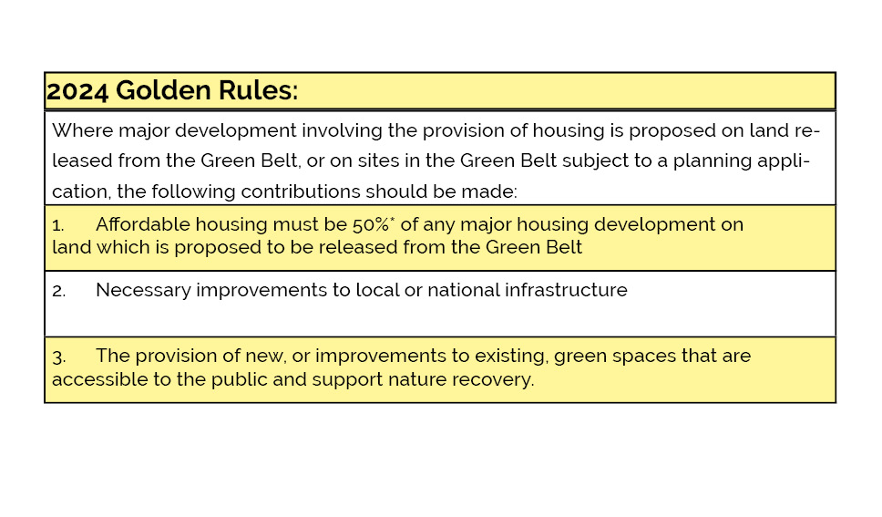
Source: adapted by R-LA from NPPF 2024
Grey Belt
At a council meeting on 12th February 2025, the councillors from Erewash Borough Council
approved plans for Bloor Homes to build 259 houses on the Derby Green Belt despite more than 550 people opposing the plans.
The proposal had previously been dubbed inappropriate and is now considered to fall under the 'grey belt' policy, providing a degree of affordable housing and a 15m buffer zone from nearby ancient woodland. The council's head of planning stated that the proposal was self contained and would not lead to the merging of towns.
James Beverley, on behalf of Bloor Homes, said the development would provide 10 per cent affordable housing on the site (26 houses) along with giving the council £5.5 million to build further homes elsewhere in the borough; more than £1 million for highway improvements; £1.6 million for school places; £258,000 for healthcare facilities and £47,000 for bus stops.
Councillors approved the plans by a vote of seven in favour to five against.
Source: Bloor Homes propose 259 homes on the Derby Green Belt
Notes:
The National Planning Policy Framework (NPPF) was first
published on 27 March 2012 and updated on 24 July 2018, 19 February 2019, 20
July 2021, 5 September 2023, 19 December 2023 and 12 December 2024. This sets
out the government’s planning policies for England and how these are expected
to be applied.
GLOSSARY ACCORDING TO NPPF 2024:
- Grey belt: For the purposes of plan-making and decision-making, ‘grey belt’ is defined as land in the Green Belt comprising previously developed land and/or any other land that, in either case, does not strongly contribute to any of purposes (a), (b), or (d) in paragraph 143. ‘Grey belt’ excludes land where the application of the policies relating to the areas or assets in footnote 7 (other than Green Belt) would provide a strong reason for refusing or restricting development.
- Brownfield land: See Previously developed land.
- Previously developed land: Land which has been lawfully developed and is or was occupied by a permanent structure and any fixed surface infrastructure associated with it, including the curtilage of the developed land (although it should not be assumed that the whole of the curtilage should be developed). It also includes land comprising large areas of fixed surface infrastructure such as large areas of hardstanding which have been lawfully developed. Previously developed land excludes: land that is or was last occupied by agricultural or forestry buildings; land that has been developed for minerals extraction or waste disposal by landfill, where provision for restoration has been made through development management procedures; land in built-up areas such as residential gardens, parks, recreation grounds and allotments; and land that was previously developed but where the remains of the permanent structure or fixed surface structure have blended into the landscape.